Search
You Searched For
Search Results
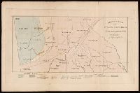
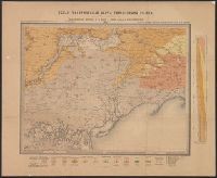
- Creator:
- Schreiber, F.
- Published / Created:
- [1845?]
- Call Number:
- BrSides 2019 8
- Image Count:
- 1
- Resource Type:
- Maps, Atlases & Globes
- Found in:
- Beinecke Rare Book and Manuscript Library > A geological map of the N-W. portion of Georgia / from a survey made in 1844-5 by F. Schreiber of Hesse Casse, G.
- Published / Created:
- 1886
- Call Number:
- 804ca 1886
- Container / Volume:
- BRBL_00545
- Image Count:
- 1
- Resource Type:
- Maps, Atlases & Globes
- Found in:
- Beinecke Rare Book and Manuscript Library > Geological map of Ohio : showing the positions of the oil and gas wells / J.N. Bradford, Del.
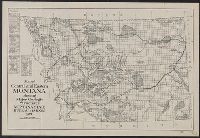
- Creator:
- Montana. State Bureau of Mines and Metallurgy
- Published / Created:
- 1921
- Call Number:
- 831ca 1921A
- Container / Volume:
- BRBL_00581
- Image Count:
- 1
- Resource Type:
- Maps, Atlases & Globes
- Found in:
- Beinecke Rare Book and Manuscript Library > Map of central and eastern Montana showing major geologic structures [cartographic material] / Montana State Bureau of Mines.
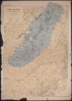
- Published / Created:
- 1893
- Call Number:
- 773cap 1893
- Container / Volume:
- BRBL_00497
- Image Count:
- 1
- Resource Type:
- Maps, Atlases & Globes
- Found in:
- Beinecke Rare Book and Manuscript Library > Map of the extinct Lake Passaic [cartographic material] : showing its outline, the position of present shore features, and the deformation that its shores have suffered / prepared by Rollin D. Salisbury and Henry B. Kummel.
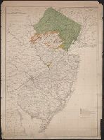
- Creator:
- Salisbury, Rollin D., 1858-1922
- Published / Created:
- [1893]
- Call Number:
- 773cam 1893
- Container / Volume:
- BRBL_00497
- Image Count:
- 1
- Resource Type:
- Maps, Atlases & Globes
- Found in:
- Beinecke Rare Book and Manuscript Library > Map showing the direction of glacial striae on the Palisade Ridge [cartographic material] / prepared by Rollin D. Salisbury and Charles E. Peet ; C.C. Vermeule, topographer.
- Creator:
- Salisbury, Rollin D., 1858-1922
- Published / Created:
- [1894?]
- Call Number:
- 773cam 1893A
- Container / Volume:
- BRBL_00497
- Image Count:
- 1
- Resource Type:
- Maps, Atlases & Globes
- Found in:
- Beinecke Rare Book and Manuscript Library > Map showing the distribution of intra-morainic glacial drift [cartographic material] / prepared by Rollin D. Salisbury ; assisted chiefly by Henry B. Kümmel and Andrew R. Whitson.
- Creator:
- Sokolov, N
Соколовъ, Н
- Published / Created:
- 1889
- Call Number:
- 352ca 1889
- Container / Volume:
- BRBL_00108
- Image Count:
- 1
- Resource Type:
- Maps, Atlases & Globes
- Found in:
- Beinecke Rare Book and Manuscript Library > Obshchai︠a︡ geologicheskai︠a︡ karta evropeĭskoĭ Russii. List 48. Melitopolʹ, Berdi︠a︡nsk, Perekop, Berislavl / sostavil N. Sokolov = Carte géologique générale de la Russie d'Europe. Feuille 48. Melitopol, Berdiansk, Perekop, Berislav / dressée par N
- Creator:
- Richards, Thomas
Sharp, G. W
Tayler, J., fl. 1861-1875
- Published / Created:
- 1876
- Call Number:
- 262ca 1876
- Container / Volume:
- BRBL_00022
- Image Count:
- 4
- Resource Type:
- Maps, Atlases & Globes
- Found in:
- Beinecke Rare Book and Manuscript Library > Sketch map of New South Wales showing the localities of the principal minerals 1876 / compiled & drawn by J. Tayler ; engraved by G. W. Sharp.
- Creator:
- Talbot, H. W. B
- Published / Created:
- 1911
- Call Number:
- 2651gfc M47 1911
- Container / Volume:
- BRBL_00023
- Image Count:
- 1
- Resource Type:
- Maps, Atlases & Globes
- Found in:
- Beinecke Rare Book and Manuscript Library > Topographical map of Meekatharra.